
Phillipine comprises of 7,000 islands normally has (20) of those every year
Super Typhoon Mangkhut hits the Philippines 03:02
Typhoon Mangkhut
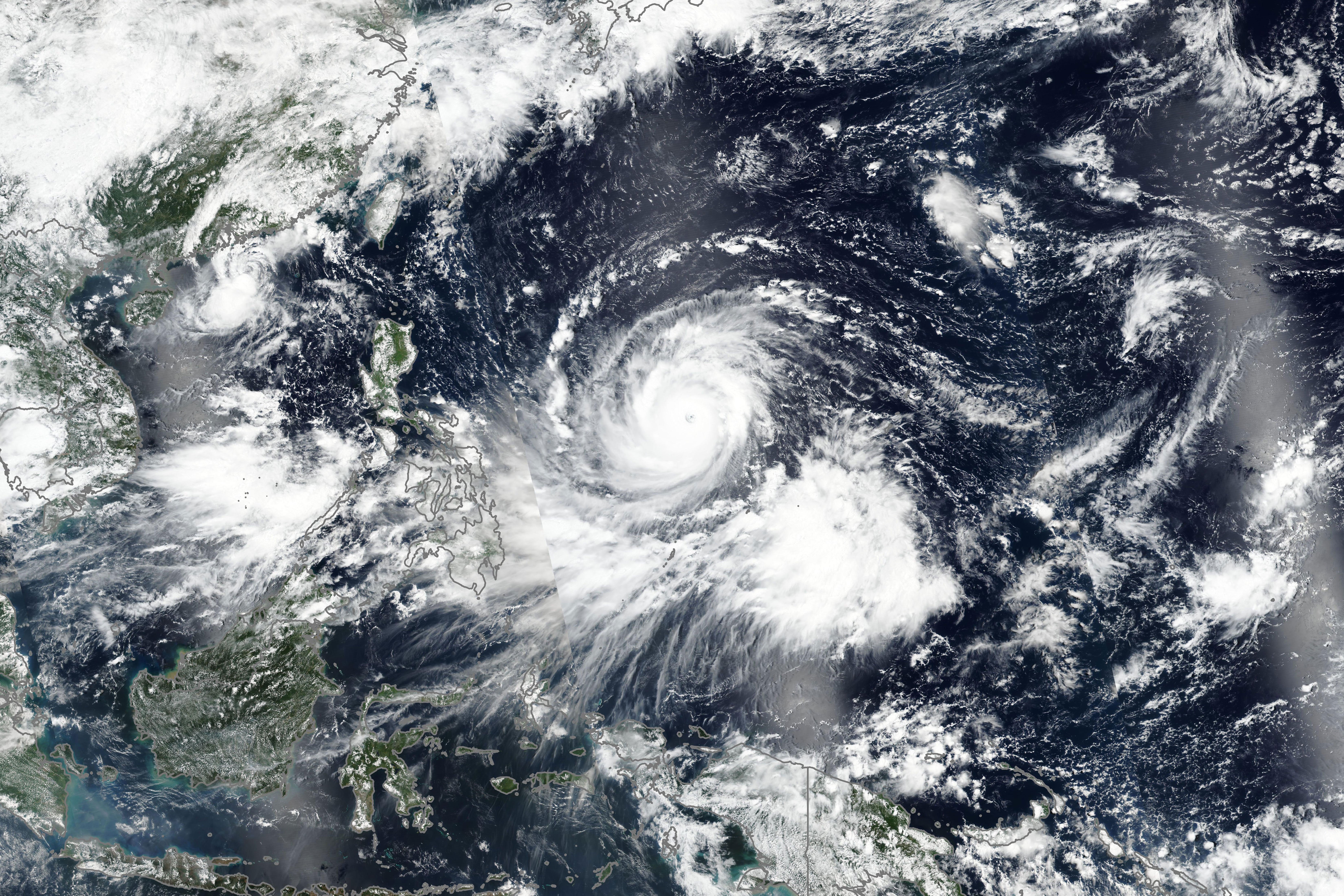
The Visible Infrared Imaging Radiometer Suite (VIIRS) on the Suomi NPP satellite acquired this natural-color image of Super Typhoon Mangkhut around midday on September 12, 2018. Around the time that the image was acquired, the U.S. Joint Typhoon Warning Center (JTWC) reported that the storm had sustained winds of 150 knots (170 miles/280 kilometers per hour), with gusts to 180 knots. Maximum significant wave heights were 41 feet (12 meters).
Mangkhut become a typhoon on September 9 and reached super typhoon strength on September 11. The JTWC predicted that the storm should cross the northern Philippines on September 14, before taking aim at Hong Kong and southeastern China on the 16th.
Super Typhoon Mangkhut hits the Philippines 03:02
Hong Kong (CNN)Super Typhoon Mangkhut has slammed into the northern Philippines, bringing with it ferocious gale-force winds and pounding rains, as aid agencies warn millions are at risk from rising flood waters and landslides.
Mangkhut, the strongest storm anywhere on the planet in 2018, made landfall in Cagayan province, on the northern tip of the Philippines island of Luzon, about 2:30 a.m. local time Saturday.
It has maximum sustained winds of 270 kilometers per hour (165 mph), with gusts as high as 325 kilometers per hour (200 mph), the equivalent of a Category 5 hurricane. As Mangkhut passes over land it is expected to weaken, before heading west into the South China Sea toward Hong Kong and southern China.
- Super Typhoon Mangkhut is hurtling through the Pacific toward Asia boasting winds as fast as 180 mph.
- Nearly 37 million people are estimated to be in the storm's path, according to the Global Disaster Alert and Coordination System.
- Mangkhut, which is equivalent to a Category 5 hurricane, has prompted mass evacuations in the Philippines and China.
- Meteorologists have warned that the storm may have a "high humanitarian impact" based on the high wind speeds and the exposed population located in vulnerable areas.
Super Typhoon Mangkhut is hurtling through the Pacific, boasting maximum wind speeds of 180 mph that threaten millions of people across Asia in what is estimated to be one of the strongest systems on record.
The system is hovering some 280 miles, or 450 kilometers, from the Philippines.
According to the Global Disaster Alert and Coordination System, the Philippines, Vietnam, and the Chinese regions of Guangdong, Hong Kong, and Macau are among places likely to be affected.
In all, nearly 37 million people are estimated to be in Mangkhut's path. GDACS estimates that the typhoon will have a "high humanitarian impact" based on the high wind speeds and the exposed population located in vulnerable areas.
Mangkhut, which is equivalent to a Category 5 hurricane, has prompted mass evacuations in the Philippines. Lt. Gen. Emmanuel Salamat, the commander of North Luzon forces, said 2,000 families had been evacuated from their homes as of Friday. Tens of thousands more have been evacuated from China's Guangdong province, CNN reported.
The super typhoon is expected to touch down on the Philippines' largest island, Luzon, on Saturday. The Philippines' flagship airline has canceled flights to cities in northern Luzon. The Philippine budget airline Cebu Pacific, along with multiple Hong Kong airlines including Cathay Pacific, also announced flight changes.
The Philippine Civil Defense chief, Ricardo Jalad, said during an emergency meeting that about 4.2 million people in the northeastern Cagayan province were vulnerable from the typhoon, which has an eye measuring 78 miles across.
According to GDACS, the storm formed over the northwestern Pacific Ocean last Friday and strengthened as it moved past the Mariana Islands and the US territory of Guam. The typhoon left parts of Guam without electricity and knocked down power poles, destroyed houses, uprooted trees, and flooded large areas, the local newspaper Pacific Daily News reported.
Mangkhut may be one of the strongest storms to hit the region
Greg Browning, a tropical climatologist with Australia's Bureau of Meteorology, told news.com.au that Mangkhut was the planet's most powerful storm system to have developed this year.
"It's extremely dangerous as it's a very large system with very strong winds and a potential storm surge over a large distance," he said. "There will be very heavy rainfall associated with it, which has potential to cause widespread damage."
The South China Morning Post on Wednesday reported that the system could turn out to be stronger than any of the 15 typhoons that have been given Hong Kong's highest warning signal and looked set to be one of the strongest to ever hit Southeast Asia.
On Friday, Philippine residents in the northeast province of Cagayan reported experiencing strong winds and heavy rain.
At the same time, extreme weather is making its presence felt on the other side of the world as well.
In the US, Hurricane Florence arrived in North Carolina on Thursday, bringing massive floods and hurricane-force winds with maximum sustained wind speeds of 90 mph in what the US National Hurricane Center has warned could be a "catastrophic" situation.
Tropical Storm Barijat is moving toward southern China, while Tropical Storm Olivia hit Hawaii with 45-mph winds
No comments:
Post a Comment